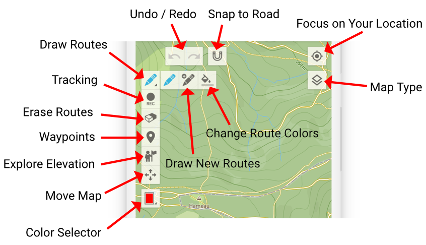

Draw Routes
The foundational tool, the pen, empowers you to draw routes with ease. Seamlessly extend your routes by dragging endpoints. Activate “Snap to Road” for effortless alignment with roads and trails.
Note: Access sub-tools (“Draw New Routes” and “Change Route Colors“) by re-selecting the “Draw Routes” tool.

Draw New Routes
Employ this tool to trace new routes across the map. Diversify your mapping endeavors by incorporating multiple routes on a single map.

Change Route Colors
Facilitate route differentiation by utilizing this tool to alter route colors. A simple tap on a route colors it in the selected color (see Color Selector).
GPS Tracking
Craft routes based on your live location. Initiate or conclude location tracking at your convenience.
Snap to Road is also working seamlessly with GPS Tracking.

Erase Routes
This versatile tool empowers you to selectively erase route segments or partition a route into distinct trajectories.

Waypoints
Effortlessly augment your routes with waypoints, utilizing this tool to seamlessly add and modify these pivotal markers.

Explore Elevation
With this tool activated, trace your finger along a route to unveil the corresponding location on the elevation profile.

Move Map
Activate this tool to manipulate the map through panning, zooming, rotation, and tilt without interacting with routes or waypoints.
Note: No matter which tool you are using, familiar navigation gestures like panning, zooming, rotation, and tilt remain accessible – except when interacting directly with a route, route endpoints or waypoint.

Color Selector
The Color Selector empowers you to choose hues, which subsequently harmonize with the “Draw New Routes” and “Change Route Colors” tools.


Snap to Road
Optimize route precision by activating “Snap to Road,” a feature that seamlessly aligns routes with adjacent roads and trails—ensuring effortless mapping even along footpaths.

Location-Centric Focus
Center the map on your present location.

Map Type
Customize your mapping view by selecting from a diverse array of map types.


Undo / Redo
Effortlessly revise your route and waypoint modifications, thanks to the versatile Undo and Redo tools.
